Geospatial Hungary - News in 2008
Goal is to provide more visibility on Hungarian developments, achievements, applications and services related to spatial data infrastructure with special emphasis on the European and Global context. HUNAGI's comprehensive News, Links and Visual Resources. Keywords: SDI, GI, GIS, Earth Observation, Satellite Navigation & Positioning, Remote Sensing, Knowledge Networking.
News are shared with the Hungarian Coordination Office for UN Spatial Data Infrastructure
Even results of satellite based radar interferometric (PSInSAR) survey case were introduced. Images: HUNAGI Visuals resource, 2008 
PopularGeosciencesLectures and Exhibitions with field training in Budapest between April 17-20
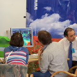
The 4-day interactive exhibition devoted to the Geosciences and the International Year of the Planet Earth attracted about 6000 visitors last week, mainly school groups and families.

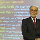
In the field of geography, cartography, thematic mapping, geoinformatics and Earth observation the following institutions attracted the visitors: ELTE TTTT, FÖMI, OMSZ, MTA TAKI, MTA GGKI and MAFI, all members of HUNAGI. Interesting pilot project using novel PSInSAR technology to detect surface movements was displayed as a joint work of ELGI and FÖMI. Opening of the event was participated by Prof. de Mulder, International Program Director of the nternational Year of the Planet Earth. Photogalleries of the event are accessible here by clicking the cover images below: and
HUNAGI proposes to its members to select the IYPE goals (www.yearoftheplanetearth.org) as main topics for the domestic events of the International GIS Day 2008 celebrated in mid November.
1st Conference on GI/SDI in LogisticsBudapest April 15, 2008So far 55 experts from the field of logistics have been registered for the First Conference on Logistics a joint venture of the Hungarian Society for Logistics (MLBKT) and HUNAGI, the Hungarian GI Association.Leaders of MLBKT and HUNAGI will welcome the participants and a keynote presentation will be delivered by the Secretary General of ITS Hungary.GNSS, cell info and WiFi supported location based services, fleet managements, commercial product dissemination will be demonstrated, RFID and sensor webs will be introduced as enabling technologies of best practice solutions. The case "Vienna airport hub Schwechat as potential innovation/knowledge node" will be presented by an expert from Austria. Energy sector and Airport logistics combined with ITS could be further topics of follow-on actions of the mentioned professional societies. For details please visit http://hunagi8.blogspot.com
 INSPIRE-related activities:News from the UK
Hayley Merill of 1spatial wrote to HUNAGI this morning:"Dear Colleague,
The 1Spatial Conference 2008, being held at the Radisson SAS Hotel, Stansted, UK, aims to be the year’s premier event focused on the transformation, integration and quality control of spatial data. Based around the theme ‘1 Source of Truth’ the conference will highlight the topics of Spatial Data Integration, Spatial Data Quality, Spatial Data Infrastructures and CAD to GIS convergence.
Specifically the conference will:
Explore the issues of spatial data integration and re-purposing across organisations e.g. EU Directive on the Re-use of Public Sector Information
Address the growing phenomenon of CAD and GIS convergence and the data management issues this presents
Discuss effective data access and sharing across the spatial data supply chain
Stimulate debate for delegates involved in establishing Spatial Data Infrastructures, such as preparing for INSPIRE implementation
Provide a forum for special interest groups across the Spatial Data Industry to meet and debate focused issues
Present delegates with an insight into all aspects of spatial data management and current best practices, including updates on issues such as Open Source and the work of the Open Geospatial Consrotium (OGC)
Speakers
The 1Spatial Conference 2008 offers you an exciting opportunity to join experts and practitioners from around the world to discuss and share experiences relating to the critical issues facing the geospatial industry today.
Confirmed speakers already include:
Katalin Tóth, European Commission Joint Research Centre
Geoff Morton, Senior Utilities Industry Director, Oracle, UK
Iain Greenway, Chief Survey Officer, Land and Property Services, Northern Ireland
Geoff Zeiss, Director of Technology, Geospatial Divsion, Autodesk, Canada
Tyler Mitchell, Executive Director, Open Source Geospatial Foundation, USA
Geoff Smith and Dan Morton, Earth Observation Group, Centre for Ecology and Hydrology, UK Dan Paull, Chief Executive Officer, PSMA, Australia
Gregory T. Reinecke, Director, LSI. USA
Brian Higgs, Geographic Management Information Systems Unit Manager, Dudley Metropolitan Borough Council, UK
Michelle Kiernan, GIS Officer, MidCoast Water, Australia
Les Hawker, Asset Manager, Transport for London, UK
Dave Lovell, Executive Director, and Antti Jakobsson, Programme Manager, EuroGeographics, France
Workshops
The 1Spatial Conference 2008 provides a unique learning environment as it plays host to the DNF Expert Group Meeting, Data Health Check Lab, HP Usability Lab and a free Metadata Seminar explaining the requirements of the INSPIRE directive; how it could be implemented and the Implementing Rules for Metadata.
INSPIRE Workshop: 'Meeting the INSPIRE requirement for Metadata' Hosted by Robin Waters, Chair of the AGI Working Group for INSPIRE, this free seminar will provide a comprehensive introduction to INSPIRE (Infrastructure for Spatial Information in Europe), covering the potential business impact of INSPIRE on stakeholders. Rob Walker, Independent Consultant and also a Member of AGI Working Group on INSPIRE, will run a workshop highlighting the Implementing Rules for metadata and how metadata can be addressed by organisations actively considering their actions around INSPIRE.
HP Usability Labs1Spatial is pleased to announce a new, exciting initiative for this year’s Conference. The HP-sponsored Usability Lab provides you with the chance to explore and discover more about state-of-the-art software in a hands-on environment. You will be able to trial and give feedback, in a non-sales environment, on software packages from a variety of 1Spatial Partners in your own time.
Data Health Check LabHosted by Salford GIS, the leading Radius Studio Practitioner in the UK, this workshop provides you with the chance to bring your own sample spatial data to the Conference. It can then be subjected to a series of standard tests to examine its overall quality from both a geometric, and logical consistency standpoint. Delegates will be encouraged to run tests themselves and will receive a report detailing the results.
DNF Expert Group MeetingThe will be a short DNF Expert Group meeting. Details will be sent out to members in due course.
GolfThe 1Spatial Golf Masters will take place at Blakes Golf Club, Epping on 29th April 2008. This is a chance to relax and network with fellow delegates and 1Spatial staff before the conference at a Championship 18 hole inland links course that is rapidly maturing into one of the top courses in the area. After the Golf participants will be able to unwind in Blakes state-of-the-art clubhouse with refreshments.
Find out more
Sponsors If you are interested in becoming a sponsor of the conference click here to download the sponsorship pack.
Register now!
Due to the success of 2007 and the limited number of places at the 2008 conference it is advisable to book early to avoid disappointment.
Kind regards
1Spatial Conference Team
Contact us at: www.1spatial.com/conference email: conference@1spatial.com
Registration now open! "
Mr. Zsolt Böszörményi, Head of RSOE Emergency and Disaster Information Services (EDIS) Budapest Hungary has sent a feedback on the HUNAGI Circular related to ISDE Summit Geoinformatics: Tools for Global Change Research, Potsdam, November 14-16, 2008. He called the attention on the webpage http://cc.rsoe.hu/ which is just devoted to the subject.
 Announcement will be given asap